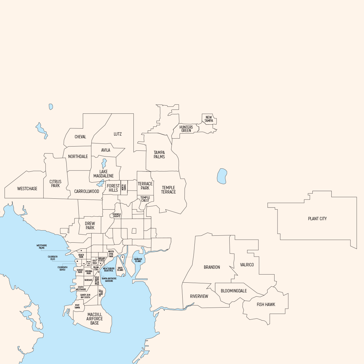
Tampa consists of five cornerstones which are Downtown Tampa, South Tampa, East Tampa, North Tampa, and Northwest Tampa.
Tampa, FL offers a vast array of Luxury Real Estate whether it’s Waterfront Homes or luxury condos with beautiful skylines. You should be able to search for both here.
The Greater Tampa Area offers so much whether it’s art museums, sports teams, plays, or festivals. You can find these in the Things To Do Section. My goal for my website is to help you “navigate” everything you will need to know about Tampa, Florida.
I hope you will enjoy visiting my website and the help it will give you. If you are looking for Real Estate, you will be able to search by area, neighborhoods, zip codes, or types of homes. There are so many choices of Real Estate whether in the city or in the many suburbs. Please reach out to me if you have questions.
I am here to help you. I also want you to know that you can reach out to me for help by calling me at (813) 546-9132 or emailing me at carlalee@kw.com.
See ya, soon!
South Tampa consists of several neighborhoods in Tampa and is located on the Interbay Peninsula. It is bordered by Tampa Bay to the west, Hillsborough Bay to the east, and West Tampa to the north. It is the area between Kennedy Boulevard to the north and MacDill Air Force Base to the south. It is an affluent community, attracting professional singles and families.
South Tampa includes the neighborhoods of Ballast Point, Bayshore Beautiful, Bayshore Gardens, Bayside West, Beach Park, Belmar Shore, Davis Islands, Fair Oaks-Manhattan Manor, Gandy-Sun Bay South, Golfview, Hyde Park, New Suburb Beautiful, Palma Ceia, Port Tampa, South Westshore, and Virginia Park. Also included are portions of Sunset Park and Courier City-Oscawana, along with MacDill Air Force Base.
If you want to be near the water, independently owned restaurants, and boutiques, South Tampa is definitely where you want to live.
Ballast Point is bordered by Hillsborough Bay, a section of the larger Tampa Bay. Its boundaries are Gandy Boulevard to the north, Hillsborough Bay to the east, MacDill Air Force Base to the south, and South MacDill Avenue to the west.
Bayshore Beautiful’s boundaries are El Prado Boulevard to the north, Bayshore Boulevard to the east, Ballast Point to the southeast, Sun Bay South to the southwest, and Virginia Park to the west.
Bayshore Gardens’ boundaries are Howard Avenue to the northeast, Bayshore Boulevard to the southeast, Bay to Bay Boulevard to the south, and the Lee Roy Selmon Expressway to the west.
Beach Park boundaries are Kennedy Blvd. to the north, Lois Avenue to the east, Beachway Drive to the south, and Tampa Bay to the west. This area was first settled by Colonel Harry Culbreath and his family who migrated from South Carolina after the Civil War.
Culbreath Bayou boundaries are Watrous Ave. to the north, Dunbar to the east, Neptune St. to the South, and West Shore Boulevard to the west. It was named after Colonel Harry Culbreath, who migrated to Tampa from South Carolina after the Civil War.
Culbreath Isles boundaries are Beach Park to the north, Westshore Blvd. to the east, and Tampa Bay to the south and west.
Davis Islands is a Tampa neighborhood and archipelago on two islands formerly known as “Little Grassy Key” and “Big Grassy Key” at the mouth of the Hillsborough River. The islands were built from mud dredged from the bottom of Tampa Bay in the 1920s and expanded.
Fair Oaks-Manhattan Manor boundaries are roughly Euclid Avenue to the north, Himes Avenue to the east, Gandy Blvd. to the south, and Manhattan Avenue to the west.
Gandy-Sun Bay South’s boundaries are Gandy Boulevard to the north, MacDill Avenue to the east, Interbay Boulevard/Everett Avenue/Tampa Bay to the south, and Tampa Bay to the west.
Golf View boundaries are Grey Gables to the north, New Suburb Beautiful to the east, Palma Ceia to the south, and Palma Ceia West to the west.
Harbour Island is situated adjacent to Downtown across the Garrison Channel. Other nearby areas include Davis Islands and Channelside. The Tampa Convention Center is located directly across the Harbour Island Bridge and Channelside is just across Beneficial Drive, both within walking distance.
The island features high-rise condominiums, apartments, row houses, single-family homes, and large houses, as well as a yacht club. A trolley connects the island to both downtown and to Channelside.
Hyde Park’s boundaries are Kennedy Blvd to the north, Hillsborough Bay to the east, Bayshore Boulevard to the east and south, and Armenia Avenue to the west. The Hyde Park neighborhood was established in the 1880s when railroad financier Henry B. Plant built the first bridge across the Hillsborough River at Lafayette Street (now known as Kennedy Boulevard).
New Suburb Beautiful is a small neighborhood within the Hyde Park district. Its boundaries are Morrison Avenue to the north, Howard Avenue to the east, the Lee Roy Selmon Expressway diagonally to the Southeast, Prospect Road to the south, and MacDill Avenue to the west.
Palma Ceia is a neighborhood located southwest of downtown Tampa. Its boundaries are Neptune Street East of MacDill Avenue to the north, the Lee Roy Selmon Expressway to the east, Miguel Street West of MacDill Avenue, and; Bay to Bay Boulevard from Dale Mabry to Himes and El Prado between Himes and the Crosstown Expressway to the south, and MacDill Avenue between Neptune and San Miguel, Dale Mabry Highway between San Miguel and Bay to Bay and Himes between Bay to Bay and El Prado to the west.
Parkland Estates boundaries are Swann Avenue to the north, Howard Avenue to the east, Morrison Avenue to the south, and Lincoln Avenue to the west.
Port Tampa is a neighborhood in the southwestern-most section in the city limits of Tampa, on the western end of the Interbay Peninsula. Its boundaries are the area south of the old east-west railroad track north of McCoy Street and west of Manhattan Avenue to Tampa Bay.
South Westshore’s boundaries are Leona Street to the north, Manhattan Avenue to the east, Gandy Boulevard to the south, and Tampa Bay to the west. It is located just south of the Westshore Business District.
Sunset Park boundaries are Beach Park Isles to the north, Culbreath Heights to the northeast, Manhattan Avenue to the east, El Prado to the south, and Tampa Bay to the west.
Virginia Park’s boundaries are Palmira Avenue/Bay to Bay Boulevard to the north, Dale Mabry Highway/Himes Ave. to the east, Euclid Avenue to the south, and Manhattan Avenue to the west.
Downtown Tampa is full of condos, high rises with first-class amenities, and the best water and skyline views. This area has continuous growth with new construction. Channelside is within walking distance to places like The Florida Aquarium, Amalie Arena which is home of Tampa Bay Lightning Hockey Team, and Riverwalk.
North Tampa comprises the city of Tampa communities of Avila, Forest Hills, Harvey Heights, Hunters Green, New Tampa, North Tampa (neighborhood), Seminole Heights, Tampa Overlook, Tampa Palms, Temple Crest, Terrace Park and University Square. This area has continuous growth with new subdivisions.
Avila is believed to be one of the most exclusive and affluent communities in Tampa. Its boundaries are Crenshaw Lake Road to the north, Lake Magdalene Boulevard to the south, and Highway 41 to the west.
Forest Hills is a neighborhood partially within the city limits of Tampa, with the northern portion located in unincorporated Hillsborough County near Lake Magdalene. The neighborhood was designed in 1926 and remains mostly as designed.
Hunters Green boundaries are Cross Creek Boulevard to the north, Highland Oak Drive to the east and Bruce B. Downs Boulevard to the west.
There are always new neighborhoods popping up throughout and families love the access to nature trails, parks, and playgrounds. New Tampa also offers golf courses and a beautiful Lower Hillsborough Wilderness Preserve. Wesley Chapel has grown into a favorite area with shopping malls, high-end retail, and a luxury community like Epperson, a community featuring a 7.5 Crystal Lagoon surrounded by white sandy beaches.
New Tampa’s boundaries are Wesley Chapel to the north, Morris Bridge Road to the east, the University community and the University of South Florida to the south, and Lutz to the west.
North Tampa offers convenient access to airports and new or remodeled home choices. North Tampa is also a neighborhood within the North Tampa community. Its boundaries are University to the north, the University Square neighborhood to the east, Sulphur Springs to the south, and Nebraska Avenue to the west.
The Seminole Heights and Tampa Heights neighborhoods offer restored historic districts. It offers more of the South Tampa Charm while maintaining suburban/historic districts. It offers conveniences of the city without noise as well as suburban amenities but close to the City of TampaSeminole Heights’ boundaries are Hanna Avenue to the north, Cherokee Avenue and Interstate 275 to the east, Osborne Avenue to the south, Florida Avenue to the west.
Tampa Palms’ boundaries are Interstate 75 to the north and east, the University of South Florida to the south, and Lutz to the west.
Temple Crest’s boundaries are Busch Boulevard to the north, Temple Terrace to the east, the Hillsborough River to the south, and 30th Street to the west.
Terrace Park’s boundaries are the University of South Florida to the north, Temple Terrace to the east, Busch Boulevard to the south, and 30th Street to the west.
The Northwest region of Tampa includes the neighborhoods of Carrollwood, Cheval, Citrus Park, Lake Magdalene, Lutz, Northdale, and Westchase. This area ranges from suburban, rural and has both new and old construction. Veteran’s Expressway makes the commute to downtown and the airport convenient. This area has continuous growth with new construction.
Carrollwood was one of Tampa Bay’s first suburbs. It is very well established and close to downtown and airport and local restaurants than some of the newer suburbs. Carrollwood’s boundaries are Lake Magdalene to the north, Tampa to the east, Egypt Lake to the south, and Carrollwood Village to the west. Major roads throughout the area include Bearss, Busch Boulevard, Dale Mabry Highway, and Fletcher Avenue.
Cheval’s boundaries are Pasco County to the north, Lutz to the east, Northdale to the south, and Keystone to the west by Keystone.
Citrus Park’s boundaries are Keystone to the north, Northdale to the northeast, Carrollwood to the east, Town ‘n’ Country to the south, and Westchase to the west.
Lake Magdalene’s boundaries are Lutz to the north, University to the east, Tampa to the South, Carrollwood to the southwest, and Northdale to the west.
Lutz’s boundaries are by Land O’ Lakes and Wesley Chapel to the north, Tampa to the east, Lake Magdalene and University to the south, and by Northdale and Cheval to the west.
Northdale’s boundaries are Cheval to the north, Lutz to the northeast, Lake Magdalene to the east, Carrollwood to the south, Citrus Park to the southwest, and Keystone to the northwest.
Westchase’s boundaries are Keystone to the north, Citrus Park to the east, Town ‘n’ Country to the south, and Oldsmar to the west.
East Tampa is in unincorporated Hillsborough County. It includes Bloomingdale, Brandon, FishHawk, Plant City, Riverview, Apollo Beach, and Valrico, among others. This area has continuous growth with new construction. Some of the Apollo Beach and Riverview communities are situated on the water with access to rivers such as the Alafia River. This unincorporated area also offers acreage
Apollo Beach, Riverview and Ruskin-Little Harbor are also referred to a somewhat new area called South Shore. This area is also home to many of Tampa’s Over 55 Neighborhoods.
Bloomingdale’s boundaries are Brandon to the north, Valrico to the northeast, FishHawk to the southeast, and Riverview to the southwest.
Brandon’s boundaries include Mango and Seffner to the north, Palm River-Clair Mel to the west, Valrico to the east, and Riverview and Bloomingdale to the south.
FishHawk is where arts and culture modern neighborhood conveniences and high-end services. FishHawk has an abundance of walking trails, public parks, playgrounds, and other recreational activities giving residents plenty of ways to connect.
FishHawk’s boundaries are the Alafia River (and then Valrico) to the north, Boyette road to the south, Riverview to the southwest, and Bloomingdale to the northwest.
Plant City is located east of the City of Tampa and is perfect for people seeking peace and quiet. Plant City is the home of Tampa’s “Strawberry Festival “ where you can find famous musicians and sweet, sweet strawberries. There are apartments, newer homes, and townhomes in Plant City however there aren’t many cookie-cutter neighborhoods. There are homes to rent and purchase that sit on nice chunks of property. Plant City is mostly agricultural. Plant City’s boundaries are Zephyrhills to the north, Lakeland to the east, Fish Hawk to the south, and Valrico and Dover to the West.
Riverview’s boundaries are Brandon to the north, the Alafia River (and then Bloomingdale) to the northeast, Fish Hawk to the east, Balm to the south, Apollo Beach to the southwest, Progress Village, and Gibsonton to the west, and Palm River-Clair Mel to the northwest.
Valrico’s boundaries include Dover to the north and east, Fish Hawk to the south, Bloomingdale to the southwest, and Brandon to the west.

Pinellas County‘s county seat is Clearwater and its largest city is St. Petersburg. Pinellas forms a peninsula whose boundaries are Tampa Bay to the east and south and by the Gulf of Mexico to the west. Clearwater, Largo, and St. Petersburg are the three largest cities in Pinellas County. Beachfront communities include (from north to south): Clearwater Beach, Belleair, Indian Rocks, Redington Beach, Madeira Beach, Treasure Island, Sunset Beach, and St Pete Beach.
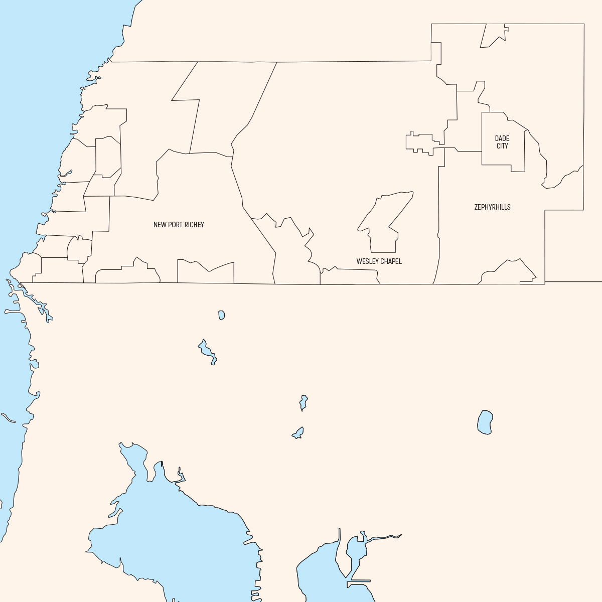
Pasco County is on the west-central coast of Florida. It includes numerous parks and trails located along rivers, the Gulf of Mexico, lakes, and highway/railroad right-of-ways. Cities in Pasco County include Dade City, New Port Richey, Wesley Chapel, and Zephyrhills.